

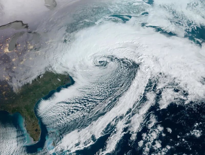
A historically powerful nor’easter winter storm has begun hammering the northeastern United States, causing widespread power outages and putting nearly 60 million Americans under winter storm warnings. As bad as the situation is on the ground, it looks downright incredible from space, as new NASA and NOAA satellite photos demonstrate.
As NOAA explains, nor’easters get their name from the direction that the strongest winds typically blow over the northeast United States, including New England and the Mid-Atlantic states. Nor’easters begin to form, as the photos show, within about 100 miles of the eastern coast between New Jersey and Georgia.
“This area is a perfect spot for the formation of storms,” NOAA explains. “The polar jet stream blows cold air southward out of Canada and eastward toward the ocean. The Atlantic Ocean is warm, thanks to the Gulf Stream–a warm ocean current.”
A low-pressure storm system forms where cold polar air meets the warmer ocean, triggering clouds and, eventually, powerful storms.
The satellite shots of the ongoing nor’easter may look a lot like a hurricane does from space, but as NOAA notes, there are some crucial differences. One of the biggest is actually where the storms occur, rather than what they look like from above. The spiraling storms, which can each be massive and cover huge swaths of land and ocean, form in different areas. Hurricanes, like nor’easters, form over the Atlantic Ocean, but much farther south. They are both types of cyclones, which are storms with winds rotating around a central low-pressure area. While nor’easters thrive on cold air, hurricanes instead are fueled by warm air.
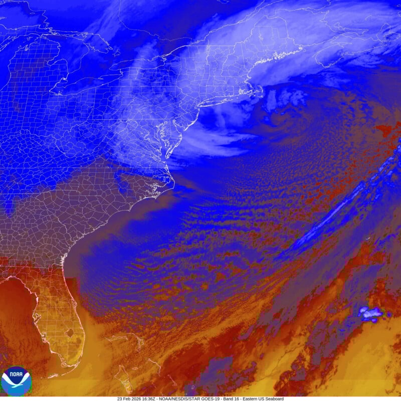
Epic satellite imagery of the historic blizzard and bomb cyclone Nor’easter slamming the Northeast.
Up to 27.5 inches of snow has fallen on Long Island, with wind gusts as high as 83 mph reported on Nantucket. pic.twitter.com/AYv92NN2yE
— Colin McCarthy (@US_Stormwatch) February 23, 2026
Morning satellite loop of the very strong Nor’Easter producing powerful winds and very heavy snow across the Northeast. Blizzard conditions and crippling impacts will continue through much of today for the region. 🛰️❄️ pic.twitter.com/VOy5UB48lh
— NWS Weather Prediction Center (@NWSWPC) February 23, 2026
Morning satellite imagery shows the “swirling eye” of powerful “bomb cyclone” off the US East Coast … New Jersey.
Functionally a hurricane
Pressure around 972 mb … maximum winds sustained 75 mph, gusts to 90 mph. pic.twitter.com/jcu2hBWmjo
— Ryan Maue (@RyanMaue) February 23, 2026
Another way in which the two storms overlap is in their destructive power.
“If you hear that a nor’easter is headed your way, prepare for very bad weather. Nor’easters can produce heavy snow and blizzards, rain and flooding, and huge crashing waves. These waves can cause erosion to the beach and severe damage to nearby buildings and structures. Nor’easters can also produce wind gusts that are even stronger than hurricane-force winds,” NOAA says.
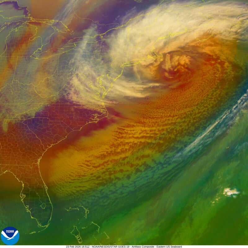
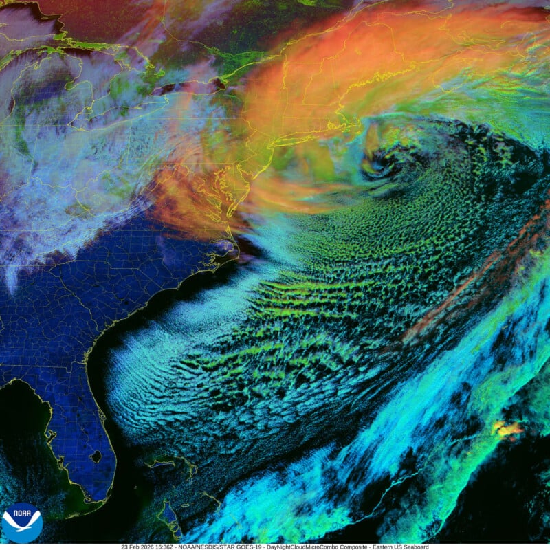
Alongside the traditional satellite imagery captured by NOAA’s GOES-19 satellite, the satellite also has enhanced camera technology that can capture storms in even greater detail. The enhanced color imagery below shows lightning flashing over the ocean as the nor’easter moved north early this morning.
While the storm looks incredible from the skies, those on the ground must take precautions to stay safe. There are already near-hurricane-force winds hitting the northeastern U.S., and it’s the biggest snowstorm in years in major cities like New York and Philadelphia. New York City is also under a city-wide travel ban, and the city had its first full-scale snow day since 2019.
Image credits: National Oceanic and Atmospheric Administration (NOAA)

